As maritime navigation and tracking becomes ever more dependent on satellite-based systems, this has also given rise to an increase in reports of Global Navigation Satellite System (GNSS) interference affecting commercial shipping routes.
What is GNSS?
The Global Navigation Satellite System comprises of 4 operational satellite constellations, that serve both civilian and military use:
- Global Positioning System (US)
- Galileo (EU)
- GLONASS (Russia)
- BeiDou (China)
These constellations, combined with ground stations and receivers, provide precise position, navigation, and timing (PNT) commonly used in aviation, maritime, and land-based applications.
The impact of GNSS interference on vessel tracking
In the context of maritime operations, GNSS interference is a deliberate tactic employed to obscure a vessel’s real-time AIS position, speed, and course, by providing a stronger, falsified signal which the receiver latches on to – this can the manifest as:
- Clustered spoofing events affecting multiple vessels simultaneously
- Position displacement to alternate/impossible locations
- Gradual drift anomalies
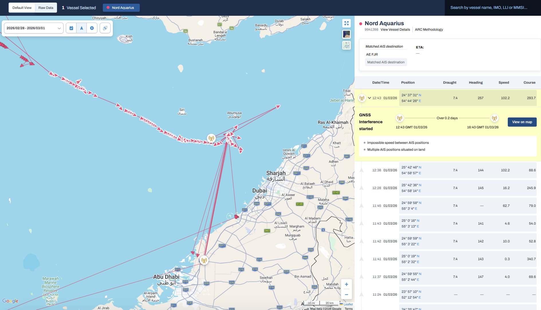
Interference events are usually commonplace in areas of geopolitical instability and conflict, but we have noted a rise in areas around trade lanes, such as the Black Sea and Persian Gulf, that are frequently used to facilitate the movement of sanctioned oil products.
Effective AIS positioning relies on accurate GNSS signals, and interference with these leads to:
- Collision and grounding risks
- Unreliable AIS tracks
- Falsified live and historical positioning
- Regulatory reporting inconsistencies
- Inaccurate logistical planning (e.g. bunker supply & ship servicing)
GNSS interference, first and foremost, does not only present a serious hazard to the safe navigation of the vessel itself, but can also cause confusion and delays during compliance screening and trading/supply planning.
Tackling the problem with Seasearcher
Uniquely enhanced to automatically detect GNSS interference events globally, Seasearcher now provides real-time validation of AIS positions likely to have been impacted – removing the guesswork of incorrectly generated voyage data, high-risk port calls and spoofing events.
Our detection models are immediately alerted when vessels display:
- Impossibly linear patterns (path aligns too closely with longitude or latitude)
- Impossible speeds reported in AIS data
- Multiple AIS positions situated on land
Examples of which are shown below for interference events that occurred in the Persian Gulf, and St Petersburg:

How this helps our customers
Adding this enhancement on top of world-class vessel tracking data and risk management solutions helps support our customers’ operational decision-making by:
- Validating reliability of AIS positions in real-time and monitoring STS activity
- Avoiding inefficient supply & logistics planning based on distorted/spoofed location data
- Clearing vessels within the short time frames required to secure viable new bunker trading opportunities
- Reducing the time spent by compliance managers interpreting unusual voyage paths and identifying the false positive voyage risks
- Speeding up the investigation of historic events affected by interference in the context of claims resolution
GNSS interference data has now been included for all Seasearcher subscribers. If you would like to know more, and schedule a demo with one of our experts.
.jpg)